
The Newspaper of Record since 1878
For current evacuation information, residents are advised to monitor Facebook pages
This item is available in full to subscribers.
To continue reading, you will need to either log in to your subscriber account, or purchase a new subscription.
If you are a current print subscriber, you can set up a free website account and connect your subscription to it by clicking here.
If you are a digital subscriber with an active, online-only subscription then you already have an account here. Just reset your password if you've not yet logged in to your account on this new site.
Otherwise, click here to view your options for subscribing.
Please log in to continue |
For current evacuation information, residents are advised to monitor Facebook pages for Pinal County Sheriff’s Office: https://www.facebook.com/PinalCountySO, Gila County Health and Emergency Management: https://www.facebook.com/gilacohealthem, and San Carlos Apache Tribe Emergency Response Commission: San Carlos Apache Tribe Emergency Response Commission - Home | Facebook.
Notifications can change rapidly. Residents in areas affected by the fire should remain vigilant and be prepared to evacuate. Evacuation notifications are issued when danger is imminent and life threatening.
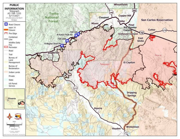
Current acreage is 171,242 with 72 percent containment and 42 structures damaged/destroyed.
Overnight, fire pushed south to Troy Mountain where firefighters worked to contain the fire’s edge. Crews scouted State Route 177 corridor for opportunities to construct containment line to protect values at risk. Crews were able to secure the Government Springs Ranch. Firefighters patrolled the Dripping Springs Road and worked on green islands of fuel which flared up. Firefighters maintained a heavy presence in the El Capitan communities, assessing damage and mopping up. Today, firefighters will continue to monitor the advance of fire from Troy Mountain toward Tiger Mountain and take suppression action where feasible. Firefighters will continue to scout State Route 77 and SR 177 corridors for opportunities to build hand line and/or dozer line, or to initiate burnouts if fire advances. Structure Protection Groups will continue to protect values at risk in the El Capitan community, and along the Dripping Springs Road. Crews will continue to clean up FR 651 to facilitate access for firefighters. In the U.S. Route 60 corridors, firefighters will continue to patrol and mop up. Extreme heat continues to adversely affect the performance of both firefighters and firefighting equipment. Afternoon temperatures yesterday caused aircraft to be grounded, and dozers to overheat. The same conditions are expected today. For information on evacuation status, road closures, and fire activity, there will be a virtual community meeting every day at 6 p.m. until further notice, on the Incident Facebook page: https://www.facebook.com/Telegraphfireinformation/
Evacuation status as of 8 a.m., June 17 for El Capitan (east and west), Dripping Springs, Wind Spirit, Hagen Ranch, Slash S Ranch and Government Springs is now “Go.”
Evacuation status for Top-of-the-World, Bellevue, Oak Flat, Beverly Hills, Six Shooter and Icehouse and is now “Set.”
Evacuation status for Superior, Globe, Miami, Claypool, Central Heights, Pinto/Carlotta, Skill Center, Fairgrounds, Schultz Ranch, Ray Mine, Riverside, Kearney, Winkelman, Hayden and the Battle Axe area is now “Ready.”
The Tonto National Forest has initiated Stage 2 Fire Restrictions for the entire forest, effective 8 a.m. on June 11. All State Land is under Stage 2 restrictions effective 8 a.m. on June 11.
The San Carlos Indian Reservation has initiated Stage 3 fire restrictions for the entire reservation, effective June 14, 2021.
All Bureau of Land Management lands in Arizona are under Stage 2 fire restrictions effective June 11, 2021. See: https://blm.gov/arizona/fire-restrictions
Closure areas: Tonto National Forest Closure Order Map: https://www.fs.usda.gov/alerts/tonto/alerts-notices Bureau of Land Management Emergency Fire Closure Order and Map: https://www.facebook.com/BLMArizona/


